Sign In
Welcome! Sign In to personalize your Cat.com experience
If you already have an existing account with another Cat App, you can use the same account to sign in here
Register Now
One Account. All of Cat.
Your Caterpillar account is the single account you use to log in to select services and applications we offer. Shop for parts and machines online, manage your fleet, go mobile, and more.
Account Information
Site Settings
Security
How to Use Drones in Construction
See how a drone program can help improve the quality, accuracy, and efficiency of your jobs.
Caitlin Maddock-Bahr | Social Media & Content Manager
Advances in technology have changed many aspects of the construction industry over the years. Equipment technology offers incredible gains in productivity and efficiency on the job site, but what if you could marry that up with additional data to help you work faster, ensure a higher quality output, and reduce costs? Have you considered adding a drone to your equipment fleet?
Drones can be used on construction sites for a wide variety of things, and with the right planning and drone program can give your business detailed, accurate, and real-time information on your site’s progress. This is information you can put to use to improve the quality, accuracy, and efficiency on the job. Some uses for drones on construction sites include:
- Improving site surveys
- Site visibility
- Progress reporting
- Safety
- Inspections
I recently caught up with Jared Harris (Field Operations Manager) and Matthew Magness (Demonstrator/Instructor) from our Tinaja Hills Demonstration and Learning Center to learn more about how they’ve seen customers benefit from drone programs, and how they use them at our facilities.
Historically, if you’re moving large amounts of dirt in construction you would measure each load with a clicker. “This amounts to a random guess of yardage moved in a day,” says Jared, “and it’s not very accurate. Flying a construction site with a drone pre-shift and post-shift can give you real data, not just a best guess, to determine quantities to know exactly where you’re at with productivity.”
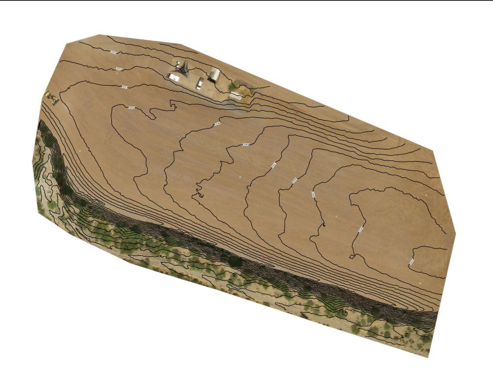
Here is an example of how drone images were used in Cat Grade Control course at our Tinaja Hills Demonstration and Learning Center last year. The design builder stitches the images together with the GPS ground control points. Trimble Business Center was used to overlay linework on the State Plane Coordinate System to make this field design.
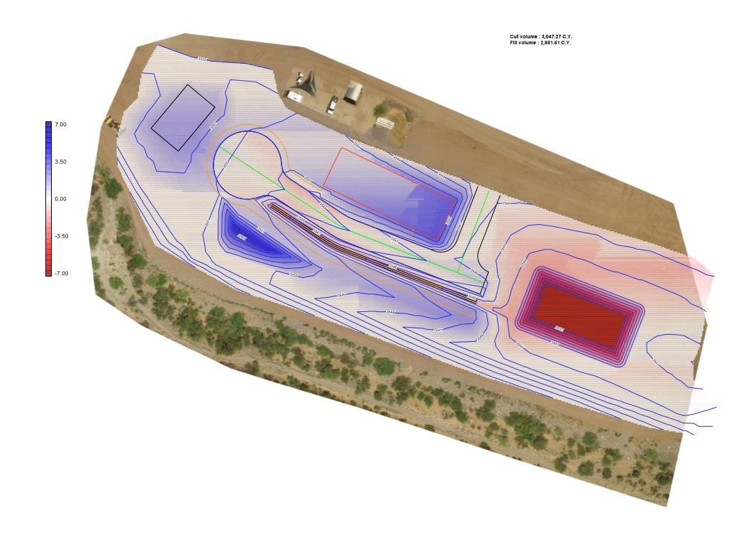
Here is an example of how drone images were used in Cat Grade Control course at our Tinaja Hills Demonstration and Learning Center last year. The design builder stitches the images together with the GPS ground control points. Trimble Business Center was used to overlay linework on the State Plane Coordinate System to make this field design.
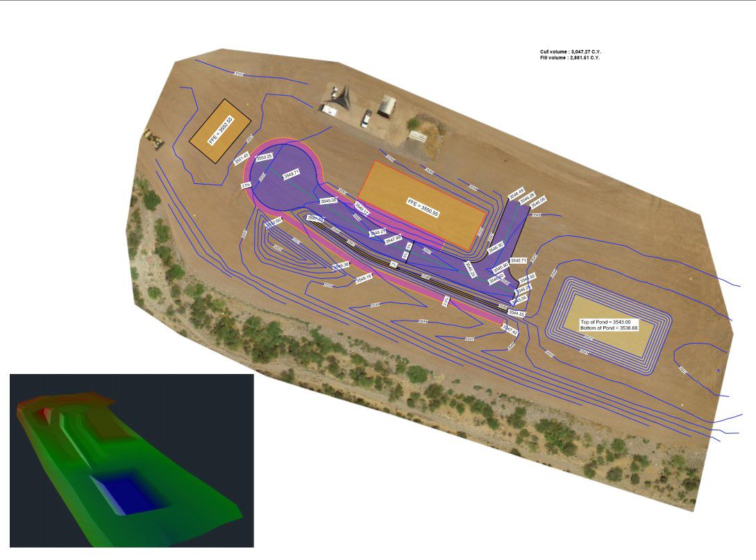
Here is an example of how drone images were used in Cat Grade Control course at our Tinaja Hills Demonstration and Learning Center last year. The design builder stitches the images together with the GPS ground control points. Trimble Business Center was used to overlay linework on the State Plane Coordinate System to make this field design.
How can drones be used on a construction site?
Using drones for site design and pre-construction activities can reduce labor times, increase accuracy of your work, and decrease the amount of rework needed on site. “It takes minutes to fly the drone, and accessing the data is quick. You would eliminate the need of having one person dedicated to checking grades all day long, which frees up another operator to move more dirt,” says Matthew.
“An engineer’s goal on the job site is to balance cuts and fills,” explains Jared. “Importing and exporting material is expensive. Using a drone to fly the site before a job starts allows you to see where cuts and fills are needed. You can build your initial design off that first cut sheet and use that to check your progress throughout the job.”
What exactly does this look like? You’ll set up ground control points, or targets, about every 300 yards to establish known elevations with GPS. After you fly your drone, the data gets imported to produce detailed maps of your job site.
Here are some specific examples of how you may benefit from adding a drone to your fleet:
- Import data and designs to your equipment
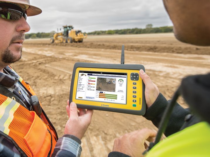
With Cat® Grade equipped machines, you can use mapping technology to map out cuts and fills. Your screen will highlight red areas for cuts, blue areas for fills, and will show green when you’re on grade. - Productivity tracking
All that grade data from the machines can be reviewed back in the office to monitor progress of the job, and the accuracy of each operator. - Progress reporting
Drone data can be used to create 3D models of your job site, which you can then use to compare your current progress against the design on a regular basis. Using this method to continually review map overlays allows you to identify discrepancies in things like building pads, ditch lines, slopes, etc. – before large amounts of rework are necessary. - Client updates
Drone images and videos are great ways to update your clients on the job’s progress. It’s also much safer and more cost effective than using a crane or hiring a helicopter.
Remember to check the airspace surrounding your job site for any restrictions. You may need to out a call in to the FAA so that they’re aware you’ll be flying in the area. You are allowed to fly 400 ft. above ground level of your launching point, and most drones will have a limiter on them that won’t allow you to go above that point.
What to look for when purchasing a drone for construction
Matthew says that camera quality is key. “You want to make sure you can capture images without dealing with pixilation. Also check for the height range of the drones you’re looking at.” At the Tinaja Demonstration and Learning Center, our teams run DJI Inspire 2 drones.
Who on your team should get trained?
All of the examples above of drones in construction are considered to be commercial use of a drone, which requires a Remote Pilot Certificate from the FAA. Jared and Matthew both suggest having someone on your team who is well-versed in surveying consider training for this pilot certificate. This is valid for two years, after which you must pass a recurrent knowledge test to retain your certificate.
Matthew highly recommends looking into online review courses and study books before taking the exam. This is essentially a small-scale pilot license, so you’ll need to be familiar with weather maps and know all the air traffic control rules.
We all know that time is money. If you’re looking for ways to get better visibility to how fast you’re moving through a job, checking accuracy, and making sure you get the right amounts of material to the right places, then a drone program might be a good investment for your business. You can make the move from old-school mathematics and grade checkers to using ground control points and drones to produce digital job site designs and boost your business’s productivity.

Caitlin Maddock-Bahr
Social Media & Content Manager
Caitlin Maddock-Bahr exercises her storytelling expertise as a social media & digital strategy manager. In this role, she not only helps Caterpillar connect with their audience, but helps customers connect with the brand.
RELATED ARTICLES
You’re here to get ideas to grow your business. Read on for machine insights and expert tips and tricks to get more out of every job.
-
Cab Technology Helps Boost Productivity
New cab technology in your Cat machine is designed to help you be more productive, work more efficiently and be less fatigued.
Learn More -
Machine Telematics
Harness the data of your machines through telematics subscriptions. Find maintenance problems early, increase productivity and save money by following our telematics guide.
Learn More -
Bid on Jobs More Accurately
Use the technology on your small wheel loader to monitor fuel consumption and costs for more accurate job bids and greater profits.
Learn More