Sign In
Welcome! Sign In to personalize your Cat.com experience
If you already have an existing account with another Cat App, you can use the same account to sign in here
Register Now
One Account. All of Cat.
Your Caterpillar account is the single account you use to log in to select services and applications we offer. Shop for parts and machines online, manage your fleet, go mobile, and more.
Account Information
Site Settings
Security
Take Efficiency to
New Heights with
UAV Technology

There’s a new piece of equipment at work on construction and quarry sites around the world. It won’t dig, push, load or haul. But it will fly– at speeds of up to 100 miles per hour–taking pictures and capturing data that can be used to improve safety, efficiency and profitability.
Some call it a “drone.”
Caterpillar prefers “UAV” (which stands for Unmanned Aerial Vehicle).
And the US government uses the term “sUAS” (which stands for small Unmanned Aircraft System).
No matter how you refer to this technology, now is a great time to learn more about it.
Start with The Fundamentals
Technology at a Glance
UAVs in Action
One Quarry’s Experience
Key Challenges
A UAV is defined as an aircraft with no pilot on board. It can be remote-controlled from the ground or it can fly autonomously, guided by a pre-programmed flight plan. UAVs can be used for recreational or commercial purposes.
- Commercial use in the US is legal if the user complies with FAA Section 14 CFR Part 107.
In our business, contractors and aggregates producers are sending camera-equipped UAVs into the air to take dozens—if not hundreds or thousands—of images. The pictures, which are linked to GPS data, can be stitched together with special software, transforming them into a 2D or 3D site model. The model can be used to:
- Assess progress on a project—daily, weekly or at some other regular interval
- Locate specific areas where work is falling behind schedule
- Measure stockpile volume
- Determine the amount of overburden that needs to be removed from an area
- Monitor width and slope of haul roads
- Analyze quarry faces and berms
- Inspect hazardous areas
- Confirm that employees are wearing protective gear and working safely
- Get a high-level view of operator technique, load-zone placement, tire rotation and other factors that affect efficiency
- Show clients work in progress
- Create images for marketing presentations and materials
These tasks and many others can be done quickly, accurately and economically with UAV systems—assuming you have access to the right technology, analytics and expertise.
Two types of UAVs are available today; a third is emerging.
- Fixed wing UAVs fly at high speeds for long periods of time. They carry large payloads over long distances and feature simple designs that are easy to maintain and repair. Their drawbacks: extra space is required for takeoff and landing so they’re less effective in tight quarters. Constant forward motion is also required so they can’t hover.
- Multi-rotor UAVs can be equipped with up to 16 rotors. Designed to take off and land vertically, they’re ideal for small spaces. They also have the capacity to hover. However, they’re significantly slower than fixed wing models so it takes more time (and more battery charges) to cover a given distance. They can also be more difficult to maintain.
- Vertical takeoff and landing UAVs are coming to market soon. They combine the speed and distance capabilities of the fixed wing design with the agility and maneuverability of the multi-rotor model.
While the type of aircraft is important, other technologies in a UAV system also play vital roles:
- Photogrammetry software transforms the images into a 3D model.
- Analytical tools help the user measure, compare and share information from the model to optimize efficiency and plan for the future.
UAVs sell at price points that range from a few hundred dollars to more than $50,000. Software and analytics can add tens of thousands of dollars to the cost of a total system.
UAV design differences |
||
Fixed wing |
Multi-rotor |
|
| Speed | Faster | Slower |
| Flight time | Longer | Shorter |
| Coverage | Larger | Smaller |
| Agility | No hovering | Hovering |
| Space requirements | More | Less |
| Maintenance complexity | Less | More |
| Cost | Higher | Lower |
Caterpillar has a small team of UAV experts whose focus is determining how the technology can be used to improve site safety, efficiency and profitability. We work with industry leaders like Trimble, who sells aircraft and software, and Redbird, a global leader in cloud-based analytics for UAVs. Together with our partners, we’re evaluating the technology on job sites in the real world. Our process is fairly simple whether we’re working with a contractor or aggregates producer.
- Clarify goals. Understanding what the equipment owner expects to do with the data drives the choice of aircraft and other factors.
- Survey Ground Control Points (GCPs). GCPs are reference points that improve the precision and accuracy of the model that will be created. These data points can be captured quickly with GPS-enabled surveying equipment.
- Program mission and upload to UAV. The mission is another word for the route the UAV will take as it flies above the site.
- Launch UAV and capture images. Typically the aircraft executes its mission without operator control. However, it can be interrupted and flown in manual mode at any time. At the end of the mission, the UAV returns to its launch point.
- Upload images to photogrammetry software. All the pictures, stored on a memory card, are uploaded to a computer where they’re turned into a 2D or 3D model.
- Use analytics platform to measure and improve operations.
We tested a fixed wing UAV in a US quarry that produces between 800,000 and 1 million tons of aggregate per year. Our pilot flew three 25-minute missions over the 350-acre site, capturing thousands of images that were converted into a 3D model within 24 hours. Had the owner gathered the information manually, the process could have taken an extra week or more. Costs and safety risks would have been higher and the data would have been less accurate. The company is using the data in a variety of ways.
- They’re calculating stockpile volume—quickly, safely and accurately—to ensure they’re paying the right amount of taxes.
- They’ve identified the next area of the site to be mined and are now planning where to put the haul road; its length, width and elevation; and how much material will be required to build it.
- They’ve calculated how much overburden will need to be removed at the next site and can now determine when to start stripping, what size fleet they’ll need and whether they should do the work themselves or hire a third party.
- They’re monitoring site activity near a creek on the property, giving them easy access to information they need to meet environmental regulations.
- They have a new aerial image of the site for the office and interesting graphics for marketing communications.
This owner—like others we’ve worked with—started the process with a general plan for using the data, but ended up finding many more ways to leverage the technology and analytics.
As we test UAVs in the US and Europe, the feedback from contractors and aggregates producers is overwhelmingly positive. But despite the enthusiasm, there are at least three challenges to be aware of:
- Regulations are changing all the time. Laws governing the commercial use of UAVs are different depending on where you do business. The United States has the tightest federal regulations, with new ones slated for 2016. Additional laws have been enacted by local governments, making it even more difficult for owners to understand and meet compliance obligations.
- Technology is racing forward. New developments in hardware, software and cloud computing are driving rapid change in UAV design, capabilities and costs. Given the pace of change, it can be difficult to choose the best path forward: buying the assets, leasing them or purchasing services from a third-party provider.
- True expertise is in short supply. A quick Google search can put you in touch with dozens of self-proclaimed drone experts. But finding a real professional with experience applying the technology in construction or aggregates is another matter. Without the right expertise, you may end up with little more than a colorful site model.
Aim High
Look for UAVs to take off in the construction and aggregates sectors over the next few months and years. As this technology evolves, you’ll be able to combine machine data from your telematics systems with geo-spatial data from UAVs—giving you the power to take site efficiency to all-new levels.
RELATED ARTICLES
You’re here to get ideas to grow your business. Read on for machine insights and expert tips and tricks to get more out of every job.
-
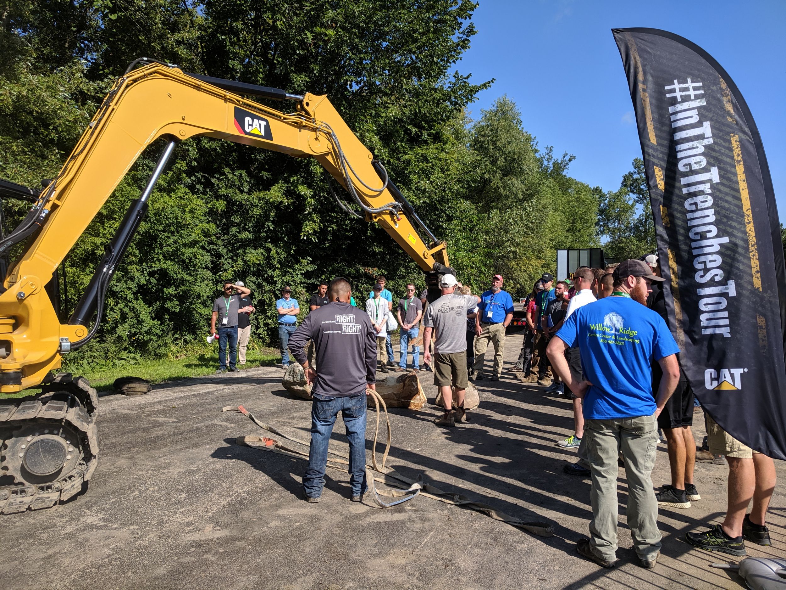
Pondemonium 2019 Recap: Taking Pride in Your Landscape Work
Serene waterfalls. Babbling brooks. Tranquil ponds. And the quiet purr of Cat® equipment in the distance … sounds like a little piece of paradise, right? That’s just what we found when we arrived at Pondemonium 2019 a few weeks ago with our In The Trenches Tour featuring Next Generation Cat Mini Excavators. This experience was like no other landscaping event in world. And we couldn’t wait to share a recap with you in the latest “On The Level” blog. If you don’t already love your job, you will after reading this!
Learn More -
How to Use Drones on Construction Job Sites
You can use drones in construction for a wide variety of things, and with the right planning and drone program can give your business detailed, accurate, and real-time information on your site’s progress. This is information you can put to use to improve the quality, accuracy, and efficiency on the job.
Learn More -
Certified Aquascape Contractors
Learn how to expand your landscape business’s services with water feature installations. Partnering with Aquascape Inc. to become a Certified Aquascape Contractor (CAC) opens up a valuable range of business opportunities.
Learn More -
When to Consider Cat® Command for Your Business
When, where and why should you consider remote technologies like Cat® Command for your business? We're walking through all the reasons you need to start planning now for the future of heavy equipment operation.
Learn More